Another solid map today.
The contributor describes the map as follows:
This is an Ortelius map. For an excellent explanation on these maps, see the website of Marcel van den Broecke, http://www.orteliusmaps.com/index.html
The translations of the text on this map are reproduced from his website with his approval:
This is the map entitled TRANSILVANIA (cartouche bottom left:) HANC VLTRA VEL TRAN/SILVANIAM, QVÆ ET PANNO/DACIA, ET DACIA RIPENSIS, VVL:/GO SIBEMBVRGEN DICITVR,/ edidit Vienne Ao 1566 Nobiliss. atque Doctiss. Ioannes Sambucus Pannonius.
The translation is: “This is Transilvania and beyond Transylvania, also called Panno-Dacia and Dacia Ripens, vulgarly called Siebenbergen, drawn in Vienna in the year 1566 by the very noble and learned Ioannes Sambucus from Pannonia”.
Centre bottom: Vallis Hatzag Vbi olim ciuitas Sarmisgethusa. Translation is: “The valley of Hatzag, where once the Sarmisgethusa lived.” If you google that name up, you get a reference to Sarmizegethusa (King's Seat) of Gradistea Munselului, in southern Rumania, this was the royal capital of the Dacian State. It is situated at a height of 3.940 feet (1.200 m) on terraced slopes deep among the southern Carpathian Mountains.
Cartouche lower middle right with four lines of text: "H..Litera in hac tabula/nonnullis vocabulis/adiuncta significat/ea esse Hungarica. Translation: “The letter H added to some names on this map means that these are Hungarian.”
Plate size: 326 x 451 mm
Scale: 1 : 500,000
Identification number: Van den Broecke Ort 153
The map occurred in various Theatrum editions, from 1575 through 1609.
Approximate number of copies printed: 6500.
Cartographic sources: Sambucus 1566, itself based on Honter 1532
Sunday, February 24, 2008
Transylvania, 1566
Categories:
1560s,
Carpathian Mountains,
Europe,
Ortelius,
Romania,
Rumania,
Sixteenth Century,
Transylvania
Saturday, February 23, 2008
Retusari, circa 1720
Today's map is a bit different from the previous entries, but an entirely worthy addition nonetheless.
The contributor offers this description of the piece: Central on this half birds eye view map you see a little island referred to as Retusari (“C” on the map), now known as the Kotlin Island. This island lies in the head of the Gulf of Finland.
Peter the Great captured the island from the Swedes in 1703 and constructed a fort and docks—then called Kronslot (on this map Cron schantz)—to protect the approaches to St. Petersburg. It is also known as Kronshtady, Kronshtadt or Kronštadt (“D” on the map) .
In the same year he founded Saint Petersburg (point “A” on the map) after reconquering the Ingrian land from Sweden in the Great Northern War. He named the city after his patron saint, the apostle Saint Peter.
The fortifications on the island were constructed very quickly. The Gulf of Finland is not very deep, so during the winter it completely freezes through. The text on this map says that 4000 men worked on them. Workers used thousands of frames of oak logs filled with stones. These were carried by horses across the frozen sea, and placed in cuttings made in the ice. Thus, several new small islands were created, and forts were erected on them, closing all access to Saint-Petersburg by the sea. Only two narrow navigable channels remained, and the strongest forts guarded them.
The map is by Gabriel Bodenehr most likely from “Force d'Europe, oder die Merkwürdigsten und Führnensten meistenteils auch Ihrer Fortification wegen Berühmtesten Stätte, Vestungen, Seehäfen, Pässe, Campa de Bataille in Europa....” (Augsburg, Ca. 1720) or perhaps from his 'Curioses Staats und Kriegs Theatrum,' Augsburg about 1730/35.
Thanks to the contributor for this great map!
Categories:
1720s,
Eighteenth Century,
Europe,
Gabriel Bodenehr,
Gulf of Finland,
Kotlin Island,
Kronstadt,
Northern Europe,
Retusari,
Russia,
St. Petersburg
Thursday, February 21, 2008
A Renewed Call for Maps
The content of Show Off Your Maps! relies on contributions from fellow map collectors of digital images of their maps. Without such generosity, this site would have no content to offer. Recently, while our viewership has continued to rise (thanks for visiting our site!), we have not received very many map submissions. So, we are re-issuing our call for maps. If you have a map you like, scan it or take a digital picture of it and send it to us at showoffyourmaps@gmail.com and we will be happy to post it on our site and include (or withhold) whatever information you want with the posting.
Send us your maps today!
Tuesday, February 19, 2008
Geneva, 1639
Today's map is another prize from the collection of Johan Huizing.
Mr. Huizing offers the following description of this wonderful work: This fine map depicts the city of Geneva and the region surrounding Lake Léman. It is by Hendrick Hondius (1597–1651) and I believe it comes from his “Nouveau Théâtre du Monde” or Nouvel Atlas of 1639. It looks a lot like the Ortelius map (no. 55 van den Broecke numbering). I like the big fish in the lake a lot!
Many thanks to Mr. Huizing for this excellent contribution!
Categories:
1630s,
Europe,
Geneva,
Hendrick Hondius,
Lake Léman,
Seventeenth Century,
Switzerland
Monday, February 18, 2008
Korea circa 1865
We're back! We took tomorrow off, sorry for the inconvenience. Today's map is another fine piece from Mr. Henny Savenije's collection.
This is a mid-19th century work of Korea is titled "Coree, par les Missionnaires de Coree de la Societe des Missions Etrangeres." This map was the work one R. Hauserman from information collected by missionaries to Korea of the Society of Apostolic Life. Thanks again to Mr. Savenije for this contribution.
Remember, send your maps to showoffyourmaps AT gmail DOT com! This site relies on your contributions.
Categories:
1860s,
Asia,
East Asia,
Korea,
Nineteenth Century,
R. Hauserman
Saturday, February 16, 2008
New Amsterdam, 1673
Today's interesting map comes to us from the collection of Jerzy Boden.
Mr. Boden supplies the following description: An extremely rare map engraved by Hugo Allard in 1673, known as the 'Restitutio' map. Shortly after the map was issued the Dutch retook the city from the English. The map was printed to celebrate the retaking of New Amsterdam from the British. Allard updated his previous plate by changing the title, some place names and most importantly by changing the view that appears in the lower right. This new view is known as the Restitutio view. It depicts a city that has increased considerably in size. Wall Street's “wall” is shown at the far right edge of the town - a wooden palisade! The Dutch returned the city to the British in November of 1674 and in return the British gave the Dutch the Spice Islands in the East Indies.
Many thanks to Mr. Boden for sharing this excellent map!
Categories:
1670s,
America,
Hugo Allard,
New Amsterdam,
New York,
North America,
Seventeenth Century
Friday, February 15, 2008
How Can We Improve This Site?
We hope you enjoy your visits to our site. Show Off Your Maps! is still a very new project, and we are always looking for ways to improve it. We see this site as a collaborative effort with our viewers, so if you can take a moment and comment on this posting to share any thoughts you have regarding making this site better, we would greatly appreciate it. Even if you don't think we should change anything, let us know!
Thanks.
Thanks.
The Empire of Alexander the Great B.C. 331-301, 1898
Today's map is a bit different from our previous entries.
The contributor has provided the following description of this piece: This colorful map comes from George F. Cram's "Universal Atlas - Geographical, Astronomical and Historical," published in 1898. This map shows the Empire of Alexander the Great and also details his routes of conquest.
Thanks to the contributor for sharing this map!
Categories:
1890s,
Asia,
Asia Minor,
Egypt,
Europe,
George F. Cram,
Greece,
Nineteenth Century,
Persia
Thursday, February 14, 2008
The World circa 1757
Today's aesthetically pleasing map is from the collection of Johan Huizing of France.
The contributor offers the following description: This is a map of the world by Thomas Jefferys, London, c. 1757. Double-hemispheric world map with a shaded area between the tropics illustrating the prevailing winds. In North America the entire seaboard is labeled “British Emp,” with Georgia, Carolina, Virginia, Maryland, New York and New England all named. The Great Lakes appear, as does the Mississippi River. In the eastern hemisphere, New Holland (Australia) is mapped in full. But except for a tiny landfall discovered in 1739, the Antarctic continent does not appear at all. In the corners are decorative figures representing the elements – fire, water, earth and air.
Our thanks to Mr. Huizing for sharing this map with us!
Categories:
1750s,
Earth,
Eighteenth Century,
Thomas Jefferys,
World
Wednesday, February 13, 2008
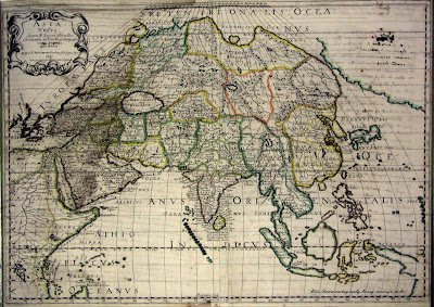
The Backside of Today's Map (Asia, 1650)
Asia, 1650
Another one from Henny Savenije's great collection.
Today's map is a mid-17th century work by N. Sanson d'Abbeville depicting Asia and the Horn of Africa. The way the political borders are drawn up reminds us of Asia on a Risk map. A big thanks to Mr. Savenije for sharing this map with us!
Remember to send your maps to us; we'll feature them here on the frontpage!
Categories:
1650s,
Asia,
Horn of Africa,
Indian Ocean,
N. Sanson d'Abbeville,
Seventeenth Century
Tuesday, February 12, 2008
Japan and Korea, 1740
Today's map comes from the excellent collection and map site of Henny Savenije.
This G. Robert de Vaugondy work from the mid-18th century named "Le Japon" features the islands of Japan and the Korean peninsula. This map is an impressively accurate piece for its time, particularly for a European cartographer. We find it interesting how the map aligns the Sea of Japan with the peninsula by naming it the "Mer de Corée."
Many thanks to Mr. Savenije for sharing this map!
Categories:
1740s,
Asia,
East Asia,
Eighteenth Century,
G. Robert de Vaugondy,
Japan,
Korea
Monday, February 11, 2008
Martinique circa 1685
Today's map is another beauty.
This Nicolas Visscher II map from the latter half of the 17th century titled "Insula Matanino Vulgo Martanico in lucem edita" displays the French Caribbean island of Martinique. A million thanks to the contributor for this great piece!
Categories:
1680s,
Caribbean,
Martinique,
Nicolas Visscher II,
Seventeenth Century
Sunday, February 10, 2008
Our First Map!
A great map to get things rolling!
Many thanks to our first contributor. The owner tells us that this fine piece of cartographic art in the Mercator style is from 1607 and displays the Abruzzo and Terra di Lovoro [sic] regions of Italy. Great map!
Be sure to send us your maps and we'll display them here!
Many thanks to our first contributor. The owner tells us that this fine piece of cartographic art in the Mercator style is from 1607 and displays the Abruzzo and Terra di Lovoro [sic] regions of Italy. Great map!
Be sure to send us your maps and we'll display them here!
Categories:
1600s,
Abruzzo,
Europe,
Italy,
Seventeenth Century,
Terra di Lovoro
Thursday, February 7, 2008
Welcome!
Welcome to our site! For a while now, we've thought to ourselves: wouldn't it be great if there was some place on the web where map collectors could get together to compare their collections and discuss map collecting? We decided to stop thinking and start doing! Show Off Your Maps is a website by map collectors, for map collectors. We're here to give collectors everywhere a place to discuss the wonderful world of antique maps and to show off what they've got. There's only one rule: have fun!
Be sure to email images of your old maps to us at showoffyourmaps AT gmail DOT com, and we'll put them right here on the site!
Subscribe to:
Posts (Atom)